Home
Factbook
Geography
History
People
Symbols
Government
Defense
Diplomacy
Economy
Contact
Tech Area
HistoryThe first known trace of human presence on Abaki territory dates from about 5000 BP, with a people of unknown origin settling on the southern shores of the Dersu river. This people, nowadays known as the Leonovits (after their discoverer, Gronkian archeologist Alexis Leonov), disappeared - also due to unknown reasons - in 3900 BP, leaving behind little more than the ruins of their stone villages.
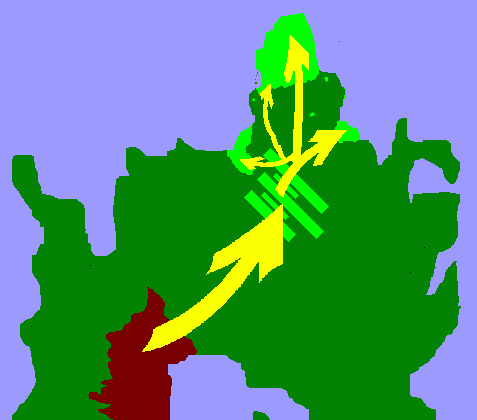
At arround 2000 BP, the Kzanikhi, a people coming from nowadays Kzanikhstan, began to expand their territory through central Eras. The Khanate, as their realm was called, had most of Kzanikhstan, Azhistan and neighbouring areas under their control by 1800 BP, although the Kzanikhi continued to migrate north, reaching the Yoakes plains arround 1750 BP and, by the following hundred years, migrating to what is nowadays Lysonia, Western Zartania, Severnaya and Abakia.
Flag of the Khanate
In dark red, the Khanate at its maximum extent (1800 BP). In light green, Kzanikhi-inhabitted areas by 1600 BP.
The borders are not exact. The yellow arrows indicate the Kzanikhi migration routes.
Khanate of the Abako in 1532 BP (aproximate borders).
As the decades passed by, the Kzanikhi were expelled from their lands in Zartania, the Yoakes and Lysonia by other peoples - of Ulanogronkian-Kralian origin, mainly. Nowadays, there is little to no trace of Kzanikhi heritage on these countries. The remaining Kzanikhi lands in northern Eras were united by Shamur Abako, who established the Khanate of the Abako with himself as Great Kahn in 1532 BP. From this point on, the Kzanikhi of northern Eras began to label themselves as Abaki.
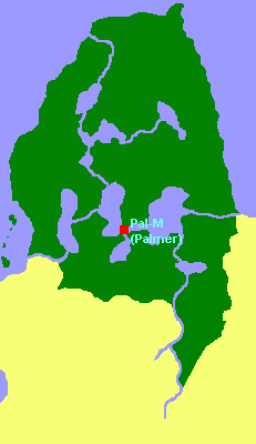
Flag of the Khanate of the Abako.For more than five hundred years, the army of the Abako managed to keep the Kralian peoples outside Abaki borders, except for the famous Raid of 1145 BP, when an army of unknown origin ransacked the Abaki capital of Pal-M (nowadays Palmer, Severnaya), killing Great Kahn Dersu Abako. All of that changed in 984 BP, when the Ulanovan Empire, on their expansion through the continent, conquered the Abako. Despite insurgent Abaki armies rising against the Ulanovans for the next fifty years, their rule was consolidated. Ulanovan customs were introduced to the Abaki, who, in the following decades, adopted their language.
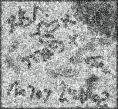
The Lakumi Stone, dated circa 970 BP and found by Alexis Leonov on 287 AP in
the Bolshoi Lakumi island, contains inscriptions on an ancient Ulanovan alphabet.
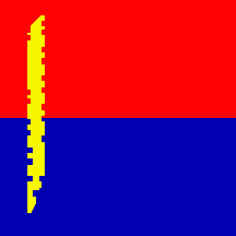
Flag of the Agron KingdomOn 960 BP, the city of Agron, a former Cruisanan colony on nowadays Ansonia, rebeled against the Ulanovans and established their Agron Kingdom, conquering much of the shores of the North Gronkian Sea. By the year 900 BP, the Abaki lands were also under their control. In 889 BP, the Kingdom of Cruisana established trading posts on Abaki territory, founding the cities of Zeljiopolis (nowadays Zelikogorod) and Lagonium (south of Verto, near the present-day Abakia-Severnaya border). They also introduced the Abaki to the Cruisan faith.
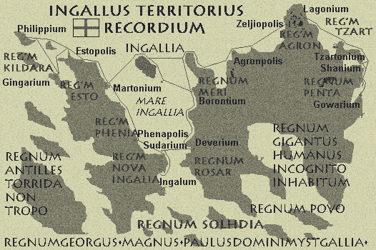
The Ingallus Territorius Recordium map, dated 800 BP. [1]Starting in 820 BP, the Agron Kingdom began to resettle ethnic Abaki further north. Ulanovan- and Ingallish-speaking Kralians were settled - forcibly or otherwise - on the areas south of the Arial and Montilliya lakes, while the entire area was renamed as the Red Sky Lakes Province. Arround 600 BP (exact date unknown), the Agron Kingdom was renamed the Gronkian Empire - or the Gronkian Kraljdom. The country was called by both names until shortly before the Great Plague, however.
Flag of the Gronkian Empire [2]Despite their territory exchanging hands several times and never again capable of forming their own independent state, the Abaki retained their common cultural identity. They never considered themselves Ulanovans or Agron or Gronkians, but Abaki. Not even the opressive "Gronkification" policies could revert this.
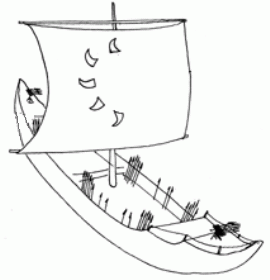
On 450 BP, an engineer named Rapi Nunkutah called Abaki for revolt against Gronkian rule. From the city of Peshaniya, he constructed and commanded a fleet of as many as fifty wooden sailships. With these vessels, he would attack Gronkian trading ships on the Red Sky Lakes, North Gronkian Sea and Perikarsian Bay and also disembark soldiers and conduct small raids on Gronkian coastal cities. Thanks to his efforts, a Second Abaki Khanate was proclaimed arround Peshaniya and Lake Arial. It was dissolved in 378 BP, after the Gronkian navy finally decimated the pirate fleet and sent a land army to the Red Sky Lakes. Rapi Nunkutah was captured and executed by Gronkian forces in Bolshoi Bereg on the 23rd of December, 376 BP. Today he is considered an Abaki national hero.
A ship of Nunkutah's Pirate Fleet. [3]
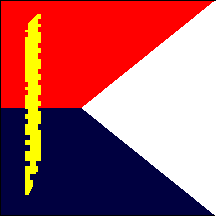
Flag of the Second Abaki Khanate
Rapi Nunkutah. Oil on Canvas by Alu Sherbarnova, 300 AP. [4]During the period when their territory was under Gronkian control, the Abaki established themselves as a seafaring society. Many officers of the Gronkian Imperial Navy were of Abaki ethnicity. By 150 BP, the small and robust Abaki fishing vessels (their design being a legacy from Nunkutah's works) could be found all arround the northern coast of Eras, from the shores of Merité to the Zartanian Norbay, and as far north as the Elafites and Zufites archipelago. This fishing was one of the main sources of food not only for the Abaki, but for all of the northern areas of the Gronkian Empire. Apart from the fish, however, the Red Sky Lakes were much negleted by the Imperial rule. If any public works were done on the province, it was due to initiative of the provincial government itself.
As the centuries passed, the Red Sky Lakes and its people continued to be ignored by Gronkian autorithies, being considered no more than a frozen wasteland - a tourist destination, at most.
Yadda: Establishment of the CCUNG.
Yadda: Fall of the CCUNG
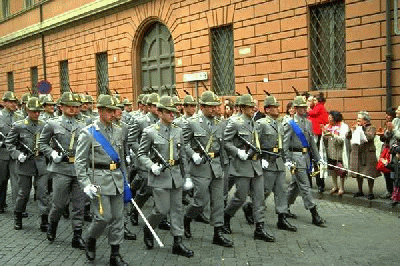
On 19th of February, 301, one of the small militias operating on the Red Sky Lakes, called the Democratic Abaco Army (DAA), marched through the provincial capital of Palmer, deposing the inefective provincial government in a bloodless coup. On that same day, DAA leader Clement Goodwood proclaimed the Democratic Republic of Abaco. Other militias and remaining civilian authorities were quick on joining the new nation.
DAA soldiers marching on downtown Palmer. [5]
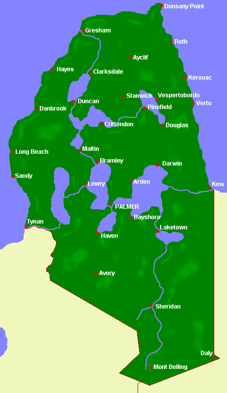
Map of the Democratic Republic
of Abaco. Note the Ingallish
names of the cities. Click for a
large version. [6]The Democratic Republic of Abaco was a Kralian-dominated socialist state. All private industry and farming lands were confiscated and nationalized by the so-called Workers' Party of Abaco and its High Council of the State, as was all the mass media. However, this socialist experience was poorly executed. The already-damaged infraestructure of the country - unpaved roads and old power lines, for exemple -, plus the inexperience of the Party bureaucrats, contributed much to the food, fuel and power shortages of the following months.
Starting on the 2nd of August, 301, troops of the Kingdom of Elaphites and Zuphites (Ezo) seized some Severnayan territory, all the lands east of Lake Smirnov. After some quick fighting, however, the invaders were expelled in no more than two weeks. Ezoan settlers brought in were allowed to stay, however, and founded the cities of Verto and Vespertobordo.
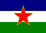
Flag of the Democratic Republic of Abaco. [7]On the 20th of August, 301, the country was renamed the Republic of Severnaya, after the Ulanovan name for the Red Sky Lakes area. By September, small voices within the Abaki people started a call for independence of the Abaki-inhabited lands. This was supressed by the Kralian-ruled media, however.
Flag of the Republic of Severnaya. [8]Yadda: abaki independence.
[TECH] Copyright notes:
[1] Edited from the original Ingallus Territorius Recordium, © Edward Mooney Jr.
[2] From the Union of Gronk / Dominion of Gronk website (www.geocities.com/arandeth/gronk/d-index.html), © Thomas Robinson.
[3] Edited from Herax Flying Longboat (www.argawarga.com/illustr.html), © Andrew Reichart
[4] Edited from character Zangief from the Street Fighter series, © Capcom Corporation.
[5] From the Republic of Severnaya website (yumusic.tripod.com/sever-old), © Filip-the-Yugoslavian
[6] From the Feniz Military Map Database (harrizbooks.vexilli.net/MilMapDB), © Filip-the-Yugoslavian
[7] Reconstruction of the Flag of the Democratic Republic of Abaco, © Risto Hepo-oja
[8] From the Republic of Severnaya website (yumusic.tripod.com/sever-old), © Filip-the-YugoslavianUnanswered Questions:
1. Is the Ingallus Territorius Recordium's Regnum Agron - and therefore, this Agron Kingdom I invented - the same as the Gronkian Empire? Is Agron the Liliani name for the Gronkians?
2. Is there any opposition to the Kzanikhi settling for a short time in Western Zartania and Lysonia?
3. Is the date of the Ezoan takeover of Severnayan territory correct?
4. Is there any opposition to anything I wrote here? I'm particulary worried about the establishment of the Gronkian Empire.
[/TECH]